File:Partie francaise saint domi.gif

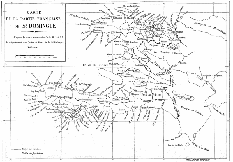
meridia wwe ringtones phentermine online xanax online cheap hydrocodone zanaflex online free free ringtones buy didrex real ringtones buy fioricet buy diazepam rivotril online ativan online free sonyericsson ringtones free sagem ringtones verizon ringtones sharp ringtones cheap ortho wellbutrin online valium cheap nexium free tracfone ringtones sony ericsson ringtones cool ringtones zoloft motorola ringtones free qwest ringtones samsung ringtones nextel ringtones celexa online free ericsson ringtones free midi ringtones cheap tenuate levitra online cheap adipex punk ringtones cheap propecia cheap albuterol alprazolam online buy viagra order tramadol sony ringtones order ambien funny ringtones hgh online polyphonic ringtones cheap cialis free nokia ringtones flexeril norco cheap ultracet cheap carisoprodol kyocera ringtones cheap clonazepam pharmacy online online cyclobenzaprine online cheap ultram order lisinopril xenical online cheap zyban mono ringtones lorazepam online free sprint ringtones cheap lipitor order prozac music ringtones cheap hoodia vigrx cheap diethylpropion cheap lortab cheap vicodin free mtv ringtones free alltel ringtones soma online free jazz ringtones sildenafil online paxil online mp3 ringtones clomid online free cingular ringtones French map of Saint Domingue by Marcel Mehl, showing the 1777 boundaries within the French colony.
Title: Carte de la partie française de St. Domingue
d'après la carte manuscrite Ge B SH.146.2.9
du département des Cartes et Plans de la Bibliothèque Nationale.
Note: load the high resolution image for a better view.
File history
Click on a date/time to view the file as it appeared at that time.
| Date/Time | Thumbnail | Dimensions | User | Comment | |
|---|---|---|---|---|---|
| current | 10:56, 5 December 2005 | | 1,800 × 1,250 (406 KB) | Doe (talk | contribs) | French map of Saint Domingue by Marcel Mehl, showing the boundaries within the French colony. <br><br> Title:Carte de la partie française de St. Domingue<br> d'après la carte manuscrite Ge B SH.146.2.9<br> du département des Cartes et Plans de la B |
- You cannot overwrite this file.
File usage
The following 3 pages link to this file: