File:Kiskeya pre colombian.jpg
From TLP
Revision as of 09:53, 11 September 2007 by Doe (talk | contribs) (Reverted edits by 190.129.118.1 (Talk); changed back to last version by Doe)

Size of this preview: 800 × 547 pixels. Other resolutions: 320 × 219 pixels | 1,500 × 1,025 pixels.
Original file (1,500 × 1,025 pixels, file size: 446 KB, MIME type: image/jpeg)
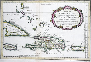
Map of pre-colombian Hispaniola, named Ayiti or Kiskeya by the native Taíno people, and it's neighboring islands.
By Jacques Nicolas Bellin (1754)
Note: for a better view, download the high resolution image
Title:
Carte de l'Isle de St. Domingue avec les Isles Voisines Suivant la Decouverte de l'Année 1492 et les Premiers Etablissemens des Espagnols
Par M. Bellin Ingénieur de la marine. (1754).
The two-dimensional work of art depicted in this image is in the public domain in the United States and in those countries with a copyright term of life of the author plus 100 years. This photograph of the work is also in the public domain in the United States (see Bridgeman Art Library v. Corel Corp.).
File history
Click on a date/time to view the file as it appeared at that time.
| Date/Time | Thumbnail | Dimensions | User | Comment | |
|---|---|---|---|---|---|
| current | 09:56, 15 November 2005 | | 1,500 × 1,025 (446 KB) | Doe (talk | contribs) | Map of pre-colombian Hispaniola, named Ayiti or Kiskeya by the native Taìnos, and it's neighboring islands. By M. Bellin (1754)<br> ''Carte de l'Isle de St. Domingue avec les Isles Voisines Suivant la Decouverte de l'Année 1492 et les Premiers E |
- You cannot overwrite this file.
File usage
The following 4 pages link to this file: