Difference between revisions of "File:Jacmel map 1799.jpg"
From TLP
m (added link) |
|||
| (One intermediate revision by the same user not shown) | |||
| Line 1: | Line 1: | ||
| − | Section of a map of the Haitian port city of [[Jacmel]] by | + | Section of a map of the Haitian port city of [[Jacmel]] by Sorrel ([[1799]]).<br><br> |
'''Title:''' Plan de la ville de Jacmel avec ses fortifications leve par le Cen. Sorrel, Ingenieur en chef du Departement de l'Ouest.<br><br> | '''Title:''' Plan de la ville de Jacmel avec ses fortifications leve par le Cen. Sorrel, Ingenieur en chef du Departement de l'Ouest.<br><br> | ||
Latest revision as of 10:53, 20 August 2007
Section of a map of the Haitian port city of Jacmel by Sorrel (1799).
Title: Plan de la ville de Jacmel avec ses fortifications leve par le Cen. Sorrel, Ingenieur en chef du Departement de l'Ouest.
Ink and watercolour.
Full size: 38 cm x 54 cm.
The two-dimensional work of art depicted in this image is in the public domain in the United States and in those countries with a copyright term of life of the author plus 100 years. This photograph of the work is also in the public domain in the United States (see Bridgeman Art Library v. Corel Corp.).
File history
Click on a date/time to view the file as it appeared at that time.
| Date/Time | Thumbnail | Dimensions | User | Comment | |
|---|---|---|---|---|---|
| current | 15:32, 18 September 2006 | 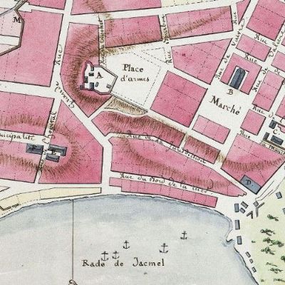 | 400 × 400 (49 KB) | Doe (talk | contribs) | Section of a map of the Haitian port city of Jacmel by I. Sonis (1799). """Title:''' Plan de la ville de Jacmel avec ses fortifications leve par le Cen. Sorrel, Ingenieur en chef du Departement de l'Ouest.<br><br> Ink and watercolour. <br> Full size: |
- You cannot overwrite this file.